Gamified Training for Localization in Orienteering - project at Chalmers/TRACKS
Orienteering project at Chalmers/TRACKS!
Project in the course Digitalization in Sports - TRA300 – 2025/26
Study period 1-2 (autumn) 2025
CHALMERS University of Technology
Read more about TRACKS.
Status: 🏁 project finished
Last update: 2025-03-17
- A team of 3 students has worked on this project.
- The multi-player localization game will be presented at O-Ringen 2026.
Background and scope
This project builds on a dataset for vision-based localization in forest environments using orienteering maps, developed during last year's course. The existing dataset consists of multiple forest runs, each including a head-mounted video, a GNSS track synchronized with the video, and a geo-referenced orienteering map. The current version is accessible at https://mldv.m2.chalmers.se/ovm.
Purpose of the work
The aims of this year’s project are:
- Expand and improve the dataset by collecting new runs in diverse forest areas, comparing first-person vs. third-person views
- Design and implement a localization training game aimed at orienteers.
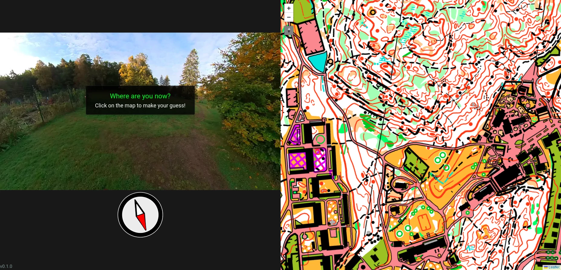
The game concept is inspired by tools like Geoguessr and Kahoot: players watch a short video sequence recorded during a forest run and try to track their location on the map in real time. At the end of the video, they guess their final position; points are awarded based on the distance between the guess and the true location. The game can have two modes: Single-player, where players train independently using past runs; Multiplayer, designed for live sessions: the video is projected in a shared space while each participant interacts with a personal map on their phone. After each round, all guesses are shown on the main screen and the scoreboard is updated.
Activities included in the project
- Defining the scope and requirements of the project
- Selecting new forest areas and planning data collection
- Expanding the dataset (video + GNSS + maps)
- Developing the game logic and interface as a web application
- Building a responsive mobile-friendly frontend for map interaction and guessing
- Testing the game in both single and multiplayer scenarios
Profile of the students
Core competencies needed (each student is expected to have at least one of the following skills, the team should cover all of them): experimental planning, orienteering, course setting in orienteering, multi-media database design, software/web development.
FAQ
-
Who can apply for this project?
Chalmers students (including exchange students), alumni, PhD students, and professionals. -
How can I apply?
By following the instructions on the course page. Please note that when you apply for the course, you have to attach your transcripts, CV, and a short motivation letter. In the motivation letter write that you are interested in this project because there are also other projects in the course. -
Do I get credits for this project?
Yes, the course TRA300 - Digitalization in sports is a 7.5hp course. There is also the possibility to extend the project to the 15hp course TRA375 - Digitalization in sports - 15hp, which includes more project work.This is a possibility to be discussed with me and the examiner of the course, Dan Kuylenstierna. -
Is the project the entire course?
The project work corresponds to 60% of the TRA300 course (equivalent to about three study weeks per student). In addition: 30% from quizzes about lectures (~8 lectures at the beginning of study period 1); 10% presentation skills. -
How many people can participate?
The projects in TRA300/TRA375 are typically carried out in groups of 2-6 students but I'm flexible to accommodate more students if needed.
Contact
Supervisor: Marco Della Vedova, Chalmers - marco.dellavedova@chalmers.se